")
")
")
")
El Chorro
Location
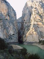
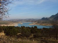
The 2,016 hectares protected by Desfiladero de los Gaitanes are located in the interior of the Subbetica mountain range, and create a spectacular landscape. They include an impressive gorge through which the River Guadalhorce flows, between enormous slabs of stratified limestone. It is considered to be of immense ecological importance. Its walls, which are up to 400 metres high, are home to a variety of plant and animal life, a clear example of adaptation to a vertical way of living.
Flora
The area’s most characteristic botanical species are: the Aleppo pine, umbrella pine, holm oak, eucalyptus, hawthorn, gorse, white rockrose, cistus and black juniper.
Fauna
The higher zones are inhabited by the mountain goat. Smaller animals such as the blackbird and the swift live in the lower areas, near the water. The middle section of the gorge is home to the falcon, kestrel and goshawk, as well as other medium-sized birds of prey. The peaks are nesting areas for large birds of prey such as the golden eagle and tawny vulture. Other inhabitants of this Beauty Spot are the wild cat, the genet, the dormouse and the mongoose, which can be seen by the more daring from a hanging walkway known as “The King’s Path” (”Caminito del Rey”), which crosses the gorge at an altitude of 100 metres.
Caminito del Rey
This small iron path hangs from the cliffs of the Sierra Huma over the “Desfiladero de los Gaitanes”. At present it is not recommended to walk along it owing to the deterioration in its condition. The walkway known as the "King’s Path” was built to connect the “Salto del Chorro” and the “Salto del Gaitanejo” both belonging to the Hydroelectric Society of El Chorro thereby allowing for the transportation of materials, ease of surveillance and the maintenance of the channel, in other words, to enable workers to move easily from one to the other. This structure is clearly visible from the railway and every visitor leaves full of admiration for the risks involved in building it and the picturesque scenery that can be viewed from there. Continuing along the walkway you cross an extremely pretty bridge that can be made out from as far away as the road to Alora al Chorro. From the bridge you can follow the footpath built into the sheer rock face, which stops at the Córdoba-Málaga railway line. The photograph shows how at times Man manages to impose his will on the grandeur of nature. This great feat of engineering was built between 1901 and 1905 and the name it bears stems from being crossed in 1921 by Alfonso the 13th when he came to inaugurate the Dam of the Conde del Guadalhorce in 1921. The “Desfiladero de los Gaitanes” is located in a region in the western part of the “Cordillera Bética” mountain range. In its entirety the gorge is over 3km long and in certain places is dominated by rock faces over 300m tall and less than 10m wide. It is hollowed out into Jurassic dolomites and limestone. Indeed rock formations from the Miocene era can also be found in the area. The most spectacular morphological feature is the vertical stratification of the limestone as fashioned by the river running through it. There are around twenty hollows in the area of the Desfiladero de los Gaitanes some of which are many metres above the flow of the river. The Desfiladero has been gradually deepened by the river in successive stages. According to the newspaper “La Opinión” (12-11-00), due to a series of fatal accidents (in the previous 3 years 5 sightseers had lost their lives) urgent repairs are planned to the deteriorating state of the walkway. The Junta de Andalucía and the Diputación de Malága are pushing for the privatization of the King’s path by taking on a private partner who would look to profit from visits by charging for access to it. This same partner would also have to contribute by jointly financing repairs to the path.