")
")
")
")
Surroundings
El Torcal Nature Reserve
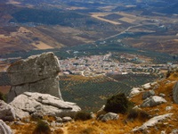
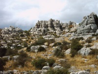
Location
Due to its unusual limestone rock formations, Torcal de Antequera Natural Park (Parque Natural Torcal de Antequera) boasts an impressive landscape that is considered to be unique in the world. Its 1,171 hectares have often been used in science fiction films. It is easy to get lost while walking in its labyrinth of rocks, depressions and valleys, passages, landings and narrow passes. The limestone nature of the terrain makes it especially susceptible to erosion by climatological agents such as rain and wind. It belongs to the Guadalhorce-El Torcal, area (13,616 hectares). In 1929, it was declared a Place of National Interest. There are many routes you can take to visit the Park, they are marked with colored signals that indicate their level of difficulty. At the reception and interpretation center you are informed.
Flora
Tree species are those typically found in mountain areas, primarily maples, elders, gall oaks, hawthorns, blackthorns and small holm oaks. The undergrowth mainly consists of scrub such as Centaurea castellana, thyme, a species of shrub known as candilera, ivy, bracken, moss, peony and irises. Also present are a number of endemic species: elms, wild blackberries and wild grapevines (on the edges of the stream).
Fauna
A wide variety of animal life, notably the rabbit, fox, wild cat and weasel as well as some Spanish goats. Vultures, falcons, eagles, sparrow hawks...
El Chorro
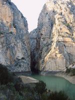
Location
The 2,016 hectares protected by Desfiladero de los Gaitanes are located in the interior of the Subbetica mountain range, and create a spectacular landscape. They include an impressive gorge through which the River Guadalhorce flows, between enormous slabs of stratified limestone. It is considered to be of immense ecological importance. Its walls, which are up to 400 metres high, are home to a variety of plant and animal life, a clear example of adaptation to a vertical way of living.
Flora
The area’s most characteristic botanical species are: the Aleppo pine, umbrella pine, holm oak, eucalyptus, hawthorn, gorse, white rockrose, cistus and black juniper.
Fauna
The higher zones are inhabited by the mountain goat. Smaller animals such as the blackbird and the swift live in the lower areas, near the water. The middle section of the gorge is home to the falcon, kestrel and goshawk, as well as other medium-sized birds of prey. The peaks are nesting areas for large birds of prey such as the golden eagle and tawny vulture. Other inhabitants of this Beauty Spot are the wild cat, the genet, the dormouse and the mongoose, which can be seen by the more daring from a hanging walkway known as “The King’s Path” (”Caminito del Rey”), which crosses the gorge at an altitude of 100 metres.
Caminito del Rey
This small iron path hangs from the cliffs of the Sierra Huma over the “Desfiladero de los Gaitanes”. At present it is not recommended to walk along it owing to the deterioration in its condition. The walkway known as the "King’s Path” was built to connect the “Salto del Chorro” and the “Salto del Gaitanejo” both belonging to the Hydroelectric Society of El Chorro thereby allowing for the transportation of materials, ease of surveillance and the maintenance of the channel, in other words, to enable workers to move easily from one to the other. This structure is clearly visible from the railway and every visitor leaves full of admiration for the risks involved in building it and the picturesque scenery that can be viewed from there. Continuing along the walkway you cross an extremely pretty bridge that can be made out from as far away as the road to Alora al Chorro. From the bridge you can follow the footpath built into the sheer rock face, which stops at the Córdoba-Málaga railway line. The photograph shows how at times Man manages to impose his will on the grandeur of nature. This great feat of engineering was built between 1901 and 1905 and the name it bears stems from being crossed in 1921 by Alfonso the 13th when he came to inaugurate the Dam of the Conde del Guadalhorce in 1921. The “Desfiladero de los Gaitanes” is located in a region in the western part of the “Cordillera Bética” mountain range. In its entirety the gorge is over 3km long and in certain places is dominated by rock faces over 300m tall and less than 10m wide. It is hollowed out into Jurassic dolomites and limestone. Indeed rock formations from the Miocene era can also be found in the area. The most spectacular morphological feature is the vertical stratification of the limestone as fashioned by the river running through it. There are around twenty hollows in the area of the Desfiladero de los Gaitanes some of which are many metres above the flow of the river. The Desfiladero has been gradually deepened by the river in successive stages. According to the newspaper “La Opinión” (12-11-00), due to a series of fatal accidents (in the previous 3 years 5 sightseers had lost their lives) urgent repairs are planned to the deteriorating state of the walkway. The Junta de Andalucía and the Diputación de Malága are pushing for the privatization of the King’s path by taking on a private partner who would look to profit from visits by charging for access to it. This same partner would also have to contribute by jointly financing repairs to the path.
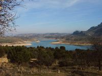
La Laguna de Fuente de Piedra
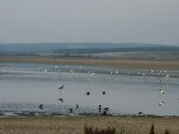
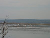
Location
Fuente de Piedra Lagoon, the largest in Andalusia, with its 164 hectares of Nature Reserve and a 1,364-hectare Protection Zone, is a unique location within the wet zones of the Western Mediterranean. It is home to the largest colony of flamingoes to be found anywhere in the Iberian Peninsula, second in importance in Europe after France’s Camargue. It is one of a group of lagoons in the Antequera area, which includes other nature reserves and covers some 3,000 hectares. A Reception and Interpretation Centre has been set up to welcome researchers from Spain and abroad. Elliptical in shape, the lagoon is replenished by rainfall and the underground flow of water provided by aquiferous land. It is also irrigated by Santillan and El Humilladero streams. Due to the extremely saline nature of the substrata, the increase in evaporation in spring leaves crytallised salt on the surface. This resource was exploited from Roman times until the 1950’s. Similar characteristics are displayed by the neighbouring lagoons of Campillos and La Ratosa, which, along with Fuente de Piedra, contribute to the maintenance of a number of aquatic bird communities.
Flora
Typical lagoon vegetation adapted to saline soils. Canes, reeds, salt cedars, sedges, rosebays. Mediterranean scrub and cereal crops.
Fauna
The largest flamingo colony in the Iberian Peninsula. The old dykes, walls and canals which were built to aid salt extraction are today essential to the nesting of the flamingo and other aquatic birds such as the Geochelidon nilotica, Larus genei, Ciconia ciconia, common goose and Anas clypeata. Other species which visit the lagoon in winter or during migratory periods include the sandpiper and a number of birds of prey.
Montes de Málaga
Location
To the north of the city of Malaga, almost completely surrounding the city, stands the Malaga Mountains Natural Park (Parque Natural Montes de Málaga). Rich in vegetation and fauna, it is better known for its country restaurants serving cured meats, local wines or those from neighbouring villages, and the typical mountain dish of French fries or breadcrumbs with spicy pork sausage and eggs. The Verdiales dance festivals are generally held here. The park is located in an area of abundant mountain streams ranging in altitude between 91 and 1,031 metres above sea level and covers 4,762 hectares. Its unusual landscape of hills and the small valleys which have formed between them, normally populated by pine trees, confer upon the area a special beauty rarely found in other mountainous regions.
Flora
Most of the area is occupied by Aleppo pine reafforestation. In the north, Aleppo pines coexist alongside holm oaks, cork oaks and gall oaks, Mediterranean species which were abundant here before their numbers dramatically dwindled. Also to be found are the lentisk, carob, kermes oak, madronno, olive and almond tree, as well as other conifers such as the umbrella pine and Monterrey pine.
Fauna
This is one of the few enclaves where the chameleon is still to be found. The polecat, weasel, wild cat, marten and wild boar also inhabit the area. Worthy of special mention among the mountains’ many birds of prey are the Hieraetus pennatus, sparrow hawk, snake and mouse eagles, goshawk and golden eagle. The most characteristic animal species are the genet, badger, fox, polecat and weasel, in addition to a considerable number of long-tailed species.
Sierra de Grazalema
Location
Declared a Biosphere Reserve by Unesco, Sierra de Grazalema Natural Park is located in the north east of the province of Cadiz and in the north west of Malaga, at an altitude ranging from 250 to 1,654 metres above sea level. A Special Protection Zone for Birds, the Park covers 51,695 hectares and is among the areas of greatest ecological importance in the south of the peninsula, and therefore of great significance in Spain as a whole. It has the highest rainfall in the Iberian Peninsula, with an annual average of over 2,000 litres per square metre, and is the most important western massif of the Subbetica range. Its heavy rainfall and limestone terrain have created a limestone landscape rich in slopes, grottoes, caves and winding gorges. The Sierra del Pinar is an important forest of Spanish firs, considered a vegetational relic of the tertiary period. Its main activities are centred on woodcutting and cattle farming (in some cases using wild stock). Industrial activities include the manufacture of woolen shawls and leather products; other sources of income are tourism, hunting and recreational fishing. Initial eco-development experiments and other development initiatives have been carried out here. Human presence in the area dates back to the Palaeolithic period and today, one of the main objectives in its management is to strike a balance between human activity and the natural environment.
Flora
The finest Spanish pine grove in the country, a vegetational relic of the tertiary period, a veritable living fossil which only grows at altitudes of over 1,000 metres, is to be found in what is known as the Sierra del Pinar (Pine Grove Mountain Range). The rest of the Park’s vegetation, clearly Mediterranean in type, includes large areas of holm-oak woods. Cork oak, gall oak and pine groves are also to be found. Carob trees, wild olives and barberries also feature, along with riverside woods and thick scrub. Spanish fir forest in the Sierra del Pinar.
Fauna
One of the largest nesting colonies of tawny vultures in Europe is to be found here. Several species of eagle can be seen: the golden eagle, Hieraetus fasciatus, Aquila heliaca, Hieratus pennatus and Circaetus gallicus. Other birds such as the goshawk and the Egyptian vulture also inhabit the Park. One of Europe’s largest bat colonies can be found here. Mammals include genets, wild boar, stags and deer.
Costa Del Sol
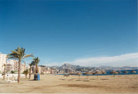
Casa Carisma is not only close to nature and history, it is also close to the beautiful beaches of the Costa del Sol. De Mideterranean beaches and harbors of amongst others Malaga, Benalmadena, Marbella, Puerto Banus,... are the touristic places to be of the region.
Origin
The Costa del Sol consists of a lot of former fishermans villages, most to the west of Malaga City, that once discovered by mass-tourism in the late sixties, have grown exponentially and clustered to one of Spain’s biggest holiday resorts.
Nerja
Once a small fishing village Nerja is now the biggest resort to the east of Málaga. There are still plenty of bars and nightclubs for those wanting to party the night away, however the old centre of the town has retained some of its original charm. The Balcón de Europa is a cliff that juts out to sea and is enclosed by two sheltered beaches, it is a favourite spot of many visitors with a beautiful view of the Mediterranean. Nerja is probably most famous for its caves which lie some 6 km inland. Discovered in 1959 by some boys chasing bats they discovered the entrance to a huge system of limestone caverns.
Torremolinos
At only a few kilometers from the airport,this was the first town to develop into the tourist industry and probably the most famous of the villages. Now it is one of the main destinations on the Costa del Sol and the beach is well established to take in a mass amount of tourists. There are plenty of souvenir shops, cafes and bars for all tasts.
Benalmádena
Is situated 2,41 km above sea level and only 2 km from the coast, is set on a plateau forming a huge balcony over the Mediterranean. Benalmádena costa is the “sister-town” on the coast and the most popular beach of the Costa del Sol. Due to the great number of people you can find a lot of activities done on the beach itself like life music or dance shows.